A Kitchen-Table Map Session for Two Neighbouring Counties
A kitchen-table map session reveals how neighbouring counties connect through shared routes, river crossings and local links beyond the county line.
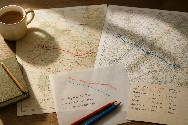
You put two county maps beside a cup of tea and notice a railway line that seems to end on one sheet, while a market town appears on both. A kitchen-table map session for neighbouring counties can begin with that small puzzle: not where one county stops, but how places on either side are connected.
Choose a shared thread—a railway, canal, bus route, market town or walking path—and follow the places it links across the map pair. The aim is to compare the relationships each map makes visible, not to reconcile county boundaries or decide which sheet is right. A route can join communities even when the maps give it different prominence.
Choose a shared thread
Pick maps that show the same adjoining area and include a clear legend. They need not use the same scale; a regional map may reveal the broad network, while a more detailed sheet can show local stops, bridges and junctions. Note each map’s title, publisher and edition information so you can tell the sources apart later.
Gather tracing paper, a soft pencil, a ruler and two coloured pencils. One person can trace a route and its named stops; the other can note towns, crossings and links to other routes. Swap roles for a second thread, such as a river crossing or a road connecting a village to a nearby market town.
Use the scale bar if you want to compare distances, and keep each map’s units and scale in view. The useful question is not simply how far apart two places look on paper, but what kinds of connection the map actually depicts.
Follow the connections
Start with a named place that appears on both maps. Trace outward from it to the next recognisable stop or junction, then note what the route joins: settlements, a station, a bridge, a canal basin or another route. Keep the route distinct from the county line; the thread of connection is the subject of this comparison.
Record what each sheet shows rather than blending the two into one polished tracing. A solid line can mark a route clearly depicted on a map; a dashed line can mark a stretch whose continuity is uncertain. Use separate colours for the two sources and write down which colour belongs to which map.
Imagine that you and a friend choose a railway linking two market towns, one on each side of a county boundary. Your starting materials are a regional map that names both towns and a detailed map that marks a station, a road crossing and an intermediate village. First, circle the two towns on both sheets. Next, trace the railway in one colour on the regional map and another on the detailed map, marking the station and village where they appear. Then compare the junctions and labels: if both sheets show the same route between the towns, your record is a clear connection with differing local detail; if one route stops at the village, leave that stretch dashed and note the discrepancy. The result is a useful account of what the maps show, without treating an omission as proof that the connection does not exist.
Notice local links
A county pair is more than two adjacent areas on a page. The routes between them may connect a village to a market, a station to a larger town, or a riverside settlement to a crossing used by roads and paths. Look for these practical links in the names and symbols around your chosen thread.
Compare how each map presents the places along the route. One may name a small settlement while another gives more space to a road junction or railway station. That difference can suggest what each map is designed to help a reader see, but it does not by itself tell you how important a place is to its residents.
For a compact record, use a table or three-column note:
- Check whether the same named starting place appears on both maps; if it does, use it as a shared anchor, and if it does not, choose a clearly labelled place shown on both.
- Check whether a route is drawn continuously between two named places; if it is, trace it as a connection, and if it is not, leave the uncertain stretch open and record the visible endpoints.
- Check whether a station, bridge or junction is labelled on each sheet; if both show it, compare its links, and if only one does, note the source rather than assuming the feature is absent.
- Check the map legend before comparing line styles; if the symbols mean the same thing, compare them directly, and if they differ, write down each legend’s meaning first.
- Check whether the maps use different scales; if they do, separate broad regional connections from local detail, and if they do not, compare the same area at the shared scale.
- Check whether a route’s name or number changes between maps; if the line still joins the same places, record both labels, and if continuity is unclear, note the two depictions without joining them by guesswork.
Keep sources distinct
Map symbols are not a universal language. A railway, path or road may be represented differently by different publishers, and labels can crowd or obscure a line. Read the legend on each sheet before interpreting its marks, then keep observations tied to their source.
Scale also changes what a map can make legible. A regional sheet may show how several towns connect, while a detailed map may reveal a station approach or minor road. When a feature appears on one map but not the other, note the difference alongside the scale and edition details rather than treating absence as a verdict.
With digital maps, keep the viewing area and zoom level consistent while comparing. The display may simplify or redraw features as you zoom, changing what catches the eye. Record the map name and the view you used, particularly if you intend to return to the comparison.
Questions about map links?
Which routes make useful comparisons?
Choose a route with named places or recognisable junctions on both maps, such as a railway between towns or a road leading to a bridge. A route with shared landmarks is easier to follow than an isolated line with no labels.
What if a route stops on one map?
Check the legend, map edge and nearby labels, then note the route’s visible endpoint. Leave any uncertain continuation unjoined until another source makes the connection clear.
Can maps with different scales still be compared?
Yes, if you treat scale as part of the comparison. Use the broader map for connections between places and the detailed one for local junctions or stops; do not mistake extra detail for a complete account.
How should we record a missing label?
Write down which map names the place and which does not, along with each map’s edition and scale. A missing label may reflect the map’s purpose or available space, so keep it separate from what you can say about the place itself.
Make the record useful
Finish with a short comparison sheet: name the route or feature, list what each map depicts, and state what remains unclear. Add the map titles and editions, and keep your coloured tracing beside—not over—the original distinctions between sources.
A kitchen-table map session for neighbouring counties is most revealing when it follows a connection through its stops, crossings and neighbouring routes. If you search for a kitchen-table map session, begin with one shared thread and record what each sheet actually shows; the resulting comparison can preserve both the connection and the differences in how it is mapped.